Kosi Flood: Facts and Observations
(In the wake of the floods in Bihar, Dr. Santosh Kumar, Former Professor, Water Resources, N.I.T., Patna, visited the spot where the breach in the Kosi embankment occurred, along with a team of the People’s Commission on Floods. Below are some of his observations.)

The desolate waterscape of flood-devastated Bihar, as far as Bihar’s two major ruling class rivals are concerned, is an arena for political one-upmanship with both Nitish Kumar and Laloo Yadav washing their hands off their own complicity in the devastation even as some 2 million victims wait for rescue and relief.
Kosi Flood Disaster
The Kosi Basin is the largest river basin in Nepal. It originates from the Tibetan Plateau of China. The seven major tributaries of Kosi drain a total area of 69,300 sq. km. before the river falls into Ganga in India, 42.4% of this area is in China, 44.3% in Nepal and 13.3% is in India. Floods in the past have created havoc in the downstream area of Nepal and India causing widespread human suffering. That is why the Kosi river is dubbed the Sorrow of Bihar. The highest flood recorded on August 24, 1954 was 24,200 cu.m/sec (8,54,615 cusecs) while the Kosi barrage has been designed for peak flood of 27,014 cu.m/s (9, 54, 000 cusecs). On August 18 this year when the embankment was breached, the discharge was only 4200 cu.m/s (1,48, 322 cusecs).
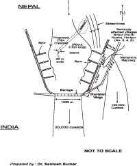
From the above data it is evident that the failure of the embankment was due to other reasons than the excessive rainfall. Progressive weakening of the spurs and embankment due to criminal neglect on the part of the engineers, contractors and bureaucrats has caused the catastrophe. When I along with other members of the People’s Commission on Floods visited the location of breach we found that the breach had occurred at 11.9 km from the Kosi Barrage and the length from the breach was 1735 m. Formation of an island upstream of the breach was also observed. It seems that the convergence of streamlines towards the poorly maintained spur put extra pressure on it, causing its failure. Consequently, failure of the embankment became a foregone conclusion.
Failure of the embankment resulted in gushing out of about 2832 cu.m/s (100,000 cusecs) water with great impact breaking into the Mahendra Rajmarg and then taking a southward route into the old 1892-1926 abandoned course of the river, thus leaving the pre-breach C-loop and following a straight route to the Ganga. Interestingly there is not much variation in the Kursela situation where Kosi falls into the Ganga.
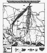
In between the breach location and Kursela when the river took the new straight route, during its journey it flooded vast areas on both sides of the new course affecting 2 to 3 million people, damaging huge property, resulting in unprecedented loss of cattle wealth and human lives.
Manpower at Breach Site
The team of engineers deployed at the breach site seem to be deficient in their knowledge of river behaviour. This is due largely to the fact that very little of river engineering is included in the engineering syllabus. There is also lot of frustration among engineers over promotion-related issues. The living conditions provided by the administration to engineers are grossly inadequate. The payment to the labour force working in the adverse and difficult situation is not compatible with the work they have to perform.

Solution to Kosi Problem
No one can claim to possess a readymade solution to the perennial Kosi problem. Two expert committees have been formed: one each by the State Government (NDA) and other by the Central Government (UPA). Unfortunately, both these expert committees seem to be guided by their master’s will rather than providing technical justification for their respective proposals.
There had been widespread opposition to the construction of embankments as a flood control measure. However, no viable alternative solution is offered by those of such an opinion, except to suggest that people should learn to live with floods.
As far as the present situation of the river Kosi is concerned, there are two possibilities; one, the breach should be sealed and the C-loop be restored and two, the river should be allowed to flow through its new course. If the first proposal is accepted, recurrence of the August 18 event cannot be ruled out and if the second proposal is executed, it will require a sizeable population to be rehabilitated. In my opinion both the old course i.e. the C-loop as well as the new course should be maintained with construction of a Head Regulator across the breached section. This will facilitate bypass of part of the discharge through the new course thus reducing the pressure on the afflux bund as well as downstream of the barrage i.e. the old C-loop. The new channel with minor channel improvement can carry sufficient discharge. This will also not require migration of many people. Of course, whatever measures are adopted, a thorough study is required before taking any major decision. Till the study is complete, pilot channel can be an effective measure to divert major portion of discharge towards the barrage. It will also facilitate construction work at the breach site.